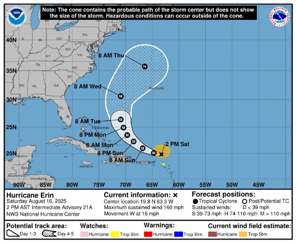
San Juan(Puerto Rico), August 16(HS): Hurricane Erin has explosively strengthened into a menacing Category 5 hurricane, with sustained winds roaring up to 160mph as it barrels westward across the Atlantic. The National Hurricane Center officially declared Erin a Category 5 on Saturday, placing it among the earliest—and fiercest—storms of the season.
Track and Impact
Erin is currently passing north of the northern Leeward Islands, hovering approximately 160 miles northwest of Anguilla and 150 miles northeast of Puerto Rico. While the United States is not projected to take a direct hit, coastal communities along the eastern seaboard are bracing for hazardous surf and elevated rip current threats in the coming days. AccuWeather’s senior meteorologist Dan Pydynowski assured, “We expect Erin to make a more northward turn and remain offshore of the U.S. East Coast. That is certainly good news given the storm’s immense strength.”
Tropical storm watches have been issued for the Turks and Caicos Islands, with conditions expected in the next 48 hours. Gusty winds and heavy rainfall are forecast to hit the southeast Bahamas starting Sunday, August 17.
Size & Growth
Erin made its debut as a hurricane on August 15, making headlines as the first hurricane and the first major hurricane—Category 3 or higher—of the Atlantic season. By midweek, meteorologists predict Erin could double or triple in size, expanding hurricane-force winds from a diameter of 43 miles to an astonishing 132 miles and tropical-storm-force winds to 385 miles.
Forecasters warn that rough ocean conditions will likely stretch across the western Atlantic as the hurricane continues to grow.
Weather Alerts & Rainfall
Outer rain bands from Erin are already lashing the northern Leeward Islands, Virgin Islands, and Puerto Rico. Predicted rainfall totals range from 2 to 4 inches, with isolated pockets up to 6 inches—raising concerns for flash flooding throughout the weekend. Erin is expected to pass north of these islands through Sunday, then skirt east of Turks and Caicos and the southeastern Bahamas Sunday night into Monday.
Intensity and Eyewall Replacement Cycle
Erin’s intensity may fluctuate over the next 24 hours, with meteorologists anticipating it will remain formidable. The hurricane is possibly undergoing an eyewall replacement cycle—a phenomenon where a newer, larger eyewall forms, extending dangerous weather over a broader area.
NOAA explains that during this cycle, hurricanes can temporarily weaken or strengthen, significantly broadening their destructive reach. What triggers these newer, larger eyewalls remains a mystery.
North Carolina’s Coastal Preparedness
As Erin tracks between Bermuda and the Outer Banks, North Carolina officials are urging coastal communities to take action:
-Review evacuation zones and routes via the Know Your Zone program.
-Secure homes and safeguard loved ones.
-Assemble emergency kits.
-Keep emergency contacts easily accessible.
The National Weather Service warns of an incoming long-period swell beginning Sunday night, with peak seas and rip currents expected from August 20 to 21. Beachgoers should heed local advisories to stay safe.
Historical Significance
Erin stands out as only the fifth Category 5 hurricane on record to form this early in the Atlantic hurricane season, and the only one recorded outside the Gulf or Caribbean at this time of year. The season officially began June 1 and typically peaks between mid-August and mid-October.
---------------
Hindusthan Samachar / Jun Sarkar


