


Hyderabad, September 2 (HS): From detecting disturbances deep beneath the sea to monitoring landslides on Himalayan slopes, modern scientific technology is playing an increasingly important role in disaster monitoring and timely warning systems. The coordinated use of satellites, radars, seismic networks and geospatial data has strengthened disaster management and early warning mechanisms.
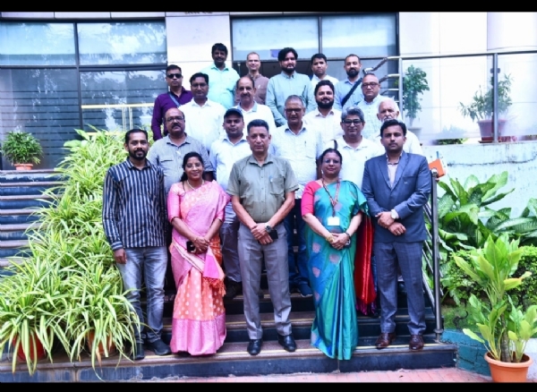
A 15-member media delegation from Uttarakhand, on a five-day Hyderabad press study tour organised by the Press Information Bureau (PIB), Dehradun, under the Ministry of Information and Broadcasting, visited PIB Hyderabad and the Indian National Centre for Ocean Information Services (INCOIS) on Tuesday, the first day of the tour. The delegation is being led by PIB Dehradun Assistant Director Sanjeev Sundriyal.
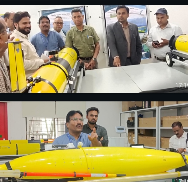
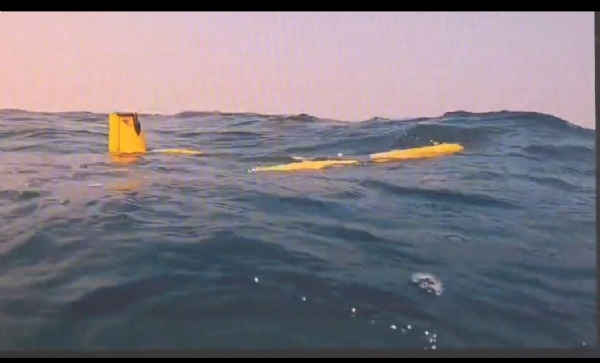
At INCOIS, functioning under the Ministry of Earth Sciences, the delegation received detailed information about India's ocean monitoring systems, the Indian Tsunami Early Warning Centre, satellite-based information systems, geospatial data and disaster warning mechanisms.
INCOIS Scientist 'E' Dr N. Srinivasa Rao and Scientist Ajay made separate presentations and explained the scientific services provided by the institution and the functioning of disaster early warning systems.
They said the Indian Tsunami Early Warning Centre continuously monitors oceanic and seismic activities. In the event of a powerful undersea earthquake, data received from multiple sources is analysed immediately to assess the possibility of a tsunami. When necessary, tsunami-related information is also shared with neighbouring countries in the Indian Ocean region.
The experts said time is the most critical factor in an early warning system. Rapid and accurate coordination of scientific systems is essential between the detection of seismic activity, analysis of ocean conditions and dissemination of warnings to potentially affected areas.
The delegation was informed that satellites are no longer limited to capturing images of the Earth. Scientific analysis of satellite-generated data helps produce useful information related to weather, ocean conditions, natural phenomena and geographical changes.
In geospatial data, the addition of latitude and longitude to information helps determine its precise geographical location. This makes it easier to map rainfall, ocean conditions, potential fishing zones and various natural phenomena.
Experts explained that satellite data is normally received at predetermined intervals, but the frequency of monitoring can be increased during severe weather events such as cyclones. Around landfall, data can be obtained at intervals of five to 10 minutes, enabling monitoring of changes in a cyclone's direction and intensity.
Doppler radars help monitor clouds and rainfall
The journalists were also briefed on the role of Doppler weather radars. Radars provide information about cloud structure, movement and moisture content, which is used to assess the possibility of rainfall.
Experts, however, pointed out that accurately predicting the exact timing and quantity of rainfall at a particular location remains a scientific challenge, particularly during monsoon conditions and rapidly changing cloud systems.
Growing role of space technology in Himalayan region
In response to questions from Uttarakhand journalists, the experts also discussed the growing scope of space-based monitoring in the Himalayan region. They said remote sensing and other space-based technologies are becoming increasingly important for studying earthquakes, landslides and glacier-related activities.
Referring to the NISAR mission, the experts explained that data obtained through microwave sensors could be useful in studying changes on the Earth's surface, landslides and glacier-related activities.
They said no single technology is sufficient for monitoring every type of disaster. Weather radars are primarily useful for monitoring clouds and rainfall, while seismic stations and other scientific systems are required for earthquake monitoring.
Coordinated analysis of data from different sources makes disaster monitoring and early warning systems more effective.
Scientific services also benefit fishermen's livelihoods
An important human dimension of INCOIS's scientific services is linked to fishing communities dependent on the sea for their livelihood. Scientific analysis of satellite-based data is used to generate information on potential fishing zones. This includes details such as the direction and distance of potential fishing areas and sea depth.
The system demonstrates how space and ocean science technologies can have a direct impact on the livelihoods of ordinary people. Data obtained from satellites is scientifically analysed and converted into useful information that can be used by communities dependent on the sea in their daily activities.
PIB officials brief delegation on communication and outreach
On the first day of the study tour, the delegation also visited PIB Hyderabad and was briefed on its communication and outreach activities aimed at disseminating information about Central Government policies, programmes and welfare initiatives.
The delegation interacted with PIB Hyderabad Additional Director General Shruti Patil, Joint Director Dr Manas Krishnakant and other officials. The officials briefed the journalists about Telangana's changing media landscape and PIB's role in disseminating information about various Central Government schemes and initiatives.
Shruti Patil said PIB and the Central Bureau of Communication (CBC) use various communication platforms and outreach activities to take government policies and programmes to the public. She said the role of factual and development-oriented journalism has become even more important amid the changing media environment.
She described press study tours as an effective means of providing journalists with first-hand information about government institutions, development projects and initiatives related to public welfare. She urged the Uttarakhand journalists to share the experiences and information gained during the Hyderabad tour with their readers and viewers.
The delegation also discussed various issues related to media, communication strategies and dissemination of information about development-oriented initiatives of the Central Government with PIB officials.
Handloom exhibition showcases India's rich weaving and handicraft heritage
During the study tour, the Uttarakhand journalists also visited a handloom and handicrafts exhibition organised in Hyderabad under the Ministry of Textiles, Government of India.
The exhibition brought together traditional weaving, handicrafts and art forms from different parts of the country. Various traditional arts and handicraft products, including Kolkonda handicrafts, Telangana's Nirmal paintings and Telangana scroll paintings, were displayed.
The journalists interacted with weavers, artisans and artists from different states and learnt about traditional techniques and distinctive features of their products.
The delegation observed that handloom and handicrafts are not only part of India's cultural identity but also an important source of livelihood for millions of weavers, artisans and their families. The exhibition highlighted efforts towards cultural preservation as well as local employment, self-employment and the rural economy.
The exhibition also showcased efforts to provide markets for traditional art forms and local products and connect weavers and artisans with a wider consumer base.
Study tour to cover scientific institutions and heritage sites
In the next phase of the study tour, the delegation will visit the ICMR-National Institute of Nutrition (ICMR-NIN) and the Employees' State Insurance Corporation (ESIC) Hospital.
The journalists will also visit the Salar Jung Museum, Charminar and Laad Bazaar, providing them an opportunity to experience Hyderabad's historical and cultural heritage.
The five-day study tour aims to provide journalists with first-hand information about major development activities of the Central Government in Telangana, scientific institutions, technological achievements, public welfare initiatives and cultural heritage, enabling them to take these experiences and information to a wider audience.
---------------
Hindusthan Samachar / Jun Sarkar
18 Aug 2026