



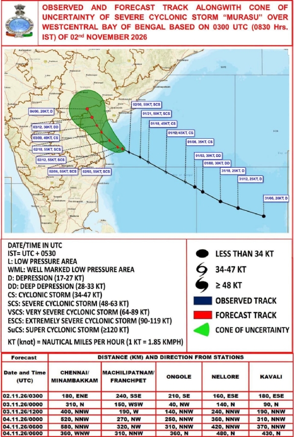
New Delhi, 02 November (H.S.): Severe Cyclonic Storm Murasu, currently active over the Bay of Bengal, is rapidly advancing towards the southern Andhra Pradesh coast and is very likely to make landfall between Nellore and Narsapur, south of Ongole, between midnight on Monday and the early hours of Tuesday. The storm is expected to bring wind speeds of 100-110 kmph, with gusts reaching up to 120 kmph during landfall.
According to the India Meteorological Department (IMD), the cyclone moved west-northwestwards at a speed of 22 kmph during the six hours preceding 8.30 am on November 2. At that time, it was centred over the west-central Bay of Bengal near latitude 14.1 degrees north and longitude 81.4 degrees east. It was approximately 160 km east-southeast of Nellore, 180 km northeast of Chennai and 210 km southeast of Ongole.
Under the influence of the cyclone, heavy to extremely heavy rainfall is forecast across several parts of coastal Andhra Pradesh between November 1 and 4. Some locations may receive rainfall exceeding 204 mm, with the impact expected to be particularly severe on November 2 and 3.
Heavy rainfall is likely in Eluru, Krishna, NTR, West Godavari, Guntur, Bapatla, Nellore and Prakasam districts.
Rainfall activity is also expected to intensify across Telangana from November 2, with extremely heavy rainfall likely in isolated areas of the state on November 3. The eastern and southern districts are expected to experience a greater impact.
Meanwhile, Tamil Nadu and Puducherry are likely to receive moderate to heavy rainfall between November 1 and 3. Isolated areas of Chennai, Tiruvallur, Chengalpattu, Kancheepuram, Puducherry and Karaikal may experience heavy to very heavy rainfall.
The cyclone is also expected to trigger heavy to very heavy rainfall in the southern Odisha districts of Gajapati, Ganjam, Koraput and Rayagada between November 2 and 4. Southern Chhattisgarh may receive heavy rainfall on November 2, with rainfall activity likely to intensify further on November 3 and 4.
Apart from these regions, isolated areas of Madhya Pradesh, Konkan, Goa and Madhya Maharashtra may also receive light to moderate rainfall.
In the Northeast, Assam, Meghalaya, Nagaland, Manipur, Mizoram and Tripura are likely to experience light to moderate rainfall until November 5. Arunachal Pradesh may also receive heavy rainfall at isolated places around November 2.
People in the affected regions have been advised to remain alert and take necessary precautions. Heavy rainfall could result in waterlogging in low-lying areas, localised flooding and disruption of normal life. The administration and meteorological authorities have urged residents, particularly those living in coastal areas, to exercise heightened caution and follow official weather advisories.
---------------
Hindusthan Samachar / Jun Sarkar

18 Aug 2026