



Chennai, 15 Nov (H.S.):
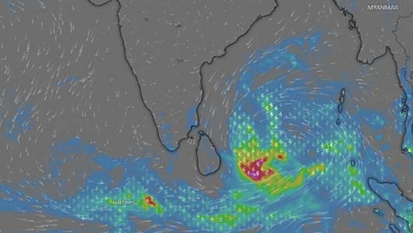
A weather system over the southeast Bay of Bengal is expected to intensify into a cyclonic storm by Monday evening and move towards the Andhra Pradesh coast, according to the forecast cited in the report.
The system, which is likely to be named ‘Akwaan’ upon developing into a cyclone, could strengthen into a severe cyclonic storm on November 17 and a very severe cyclonic storm by November 19.
The India Meteorological Department has indicated that the system will gather strength over the next two days while moving north-northwestwards. It was reported to be centred approximately 840 kilometres southeast of Chennai.
The low-pressure area over the southeast Bay of Bengal became more marked around 5.30 a.m. on Saturday and continued to strengthen as it moved northwestwards on Sunday.
By Monday evening, the system is expected to develop into a cyclonic storm over the central parts of the south Bay of Bengal and the adjoining west-central Bay of Bengal, according to the Chennai meteorological centre.
Heavy rainfall warnings have been issued for the Andaman Islands, Andhra Pradesh, Odisha and West Bengal in anticipation of the system’s intensification. Its projected movement towards Andhra Pradesh places the eastern coastline under close weather watch.
However, the information provided does not specify a likely landfall location or timing.
Meanwhile, the Chennai meteorological centre has also identified an atmospheric trough over the southwest Bay of Bengal and the adjoining equatorial Indian Ocean. The trough extends towards the northern Maldives from the circulation associated with the weather system over the southeast Bay of Bengal.
A separate upper-air cyclonic circulation persists over southern Tamil Nadu and neighbouring areas.
These additional atmospheric features form part of the broader weather conditions affecting the region as the developing Bay of Bengal system continues its movement and intensification over the coming days.
---------------
Hindusthan Samachar / Arun Lakshman

18 Aug 2026